 The CRVWA is a membership driven organization, and our members include Urban and Rural Municipalities, Resort Villages, Regional Parks, Conservation & Development Area Authorities, Wildlife Federations, and other special interest groups. Our organization began in September 2008, when Saskatchewan Watershed Authority (Saskatchewan Water Security Agency) planners approached stakeholders in the Carrot River Watershed to launch source water protection planning. Over the course of the next three years, this collaborative planning process brought together government, non-government agencies, and local stakeholders to identify threats to source water quantity and quality and to create a forum for stakeholders to participate in the development of strategies that contribute to sound water management. The results of the planning process were the establishment of the Carrot River Valley Watershed Association Inc. (CRVWA) in October 2011 and the publication of the Carrot River Watershed Source Water Protection Plan in March 2012.
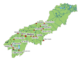
The Carrot River Watershed is located in east central Saskatchewan and is part of the Saskatchewan River basin. Crossing the provincial border into Manitoba, the Carrot River Watershed covers a total area of approximately 17,500 square kilometers, with nearly 15,750 square kilometers of this total located in Saskatchewan. This area includes the City of Melfort, Towns of Arborfield, Carrot River, Kinistino, St. Brieux, Star City, Tisdale and Wakaw, 11 villages, 21 Rural Municipalities and 6 First Nations. The estimated population is approximately 25,500 people, with approximately 13,500 of this total classified as rural residents and 12,000 classified as urban residents.
The Carrot River is the dominant watercourse in the watershed, and its headwaters originate in the Cudworth and Tiger Hill Plains near the Town of Wakaw. The outlet of Wakaw Lake marks the beginning of the Carrot River and, from there, this river flows northeast through the Melfort and Red Earth Plains until to joins into the Saskatchewan River west of The Pas, Manitoba. The Carrot River is about 300 km in length and it parallels the course of the South Saskatchewan and Saskatchewan Rivers. In fact, the distance between these rivers never exceeds 50 km, while the width of the Carrot River watershed never exceeds 80 km (SaskWater 1994). The Pasquia Hills form the southeastern border of the watershed and contribute a significant amount of water to the Carrot River. Tributaries of the Carrot River include Coldwell Creek, McCloy Creek, Dead River, Goosehunting Creek, Melfort Creek, Sweetwater Creek, Leather River, Presbyterian River, Doghide River, Crooked River, Burntout Brook, Jordan River, Papikwan River, Cracking River, Man River, Rice River, Sandhill Creek, Little Bridge Creek and Emmons Creek. The Lenore Lake internal drainage basin is within the Carrot River Watershed, and is home to several saline water bodies.
To preserve the beauty, diversity, and integrity of the watershed, the CRVWA works to raise awareness and understanding by promoting sustainable environmental, economic and cultural activities. The CRVWA believes that a community that is fully aware of the importance and vulnerability of its water resources is a community that will actively support and participate in efforts to protect these water resources. The CRVWA strives to achieve our mission through grassroots activities including educational programs in schools;implementing urban and rural stewardship programs and projects; promoting source water protection with local governments and the public;facilitating partnerships; and developing and delivering newsletters, fact sheets, workshops, and seminars for the public. The CRVWA is a member of the Saskatchewan Association of Watersheds and works collaboratively with other watershed stewardship groups while maintaining a local focus. The CRVWA is governed by a Board of Directors which includes representatives from our member organizations, and the day to day operation of the CRVWA is conducted by our Watershed Manager.
